In Part -1 of the “Finding your way around Manhattan” series, we saw how Manhattan is laid out. Now let’s have a look at the different neighborhoods or regions within Manhattan – trust me, these are the names you would keep hearing often!
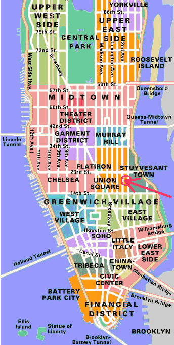
The following are the various neighborhoods of Manhattan, going from South to North (You might find the Streetwise Manhattan Map useful – it is a folding, pocket size street map of Manhattan)

Manhattan Neighborhoods Map
(Image source)
Financial District
This is the region south of Chambers Street in downtown (South) Manhattan. It forms the southern tip of Manhattan. It is sometimes also called Lower Manhattan or FiDi.
This is the hub of most financial activity of NYC – it contains offices of almost all major financial institutions, as well as the world famous New York Stock Exchange and Wall Street.
Some of the tourist attractions here include:
- WTC / Ground Zero
- South Street Seaport
- Federal Hall National Memorial
- Museum of American Finance
- Museum of American Indians
- Museum of Jewish Heritage
- Skyscraper Museum
Read articles about Financial District
Tribeca
Tribeca stands for “Triangle Below Canal Street” – and hence also written as TriBeCa at times. This is the area between Canal Street, West Street, Broadway, and Chambers Street.
This neighborhood used to be a center of the textile and cotton trade, but is now an expensive residential neighborhood. It contains a large number of restaurants, though.
Holland Tunnel that connects New York (NYC) to New Jersey (Jersey City) is located in Tribeca.
Chinatown
This is the area that falls between Chambers Street & Delancey Street, and E Broadway & Broadway.
Chinatown in NYC is one of the oldest ethnic Chinese enclaves outside of Asia. The area contains Chinese grocers, fish sellers, toy sellers, jewelry shops, beauty shops, and street vendors selling imitation items like perfumes, watches, and hand bags.
SOHO
SOHO stands for “South of Houston Street” – and hence also written as SoHo at times. This is the area between Canal Street & Houston Street and Lafayette Street & Varick Street.
Tip:” Houston” in Houston Street is pronounced as “how-ston” and not “huse-ton”
The area is famous for art and the artists living there (usually in lofts – because of their large areas and large windows). It is also famous for its cast iron buildings. It houses many upmarket boutiques and bars.

Manhattan Neighborhoods Map
(Image source)
Little Italy
This is the area between Canal Street & Broome Street along Mulberry Street. It used to house a large Italian population earlier, but now has very mixed inhabitants. Its “Italian” heritage is now limited to Italian restaurants in the area.
Read articles about Little Italy
Lower East Side
This is the area between Canal Street & Houston Street, and between Bowery & east river.
It used to be an immigrant – working class neighborhood, but it now houses upscale boutiques and fine dining places along the Clinton Street restaurant row.
Read articles about Lower East Side
West Village (West Greenwich Village)
This is the area between Houston Street to W14th Street, and between 6th Avenue & Hudson river. This is primarily a residential area which has a presence of many restaurants, bars and shops – especially the Meatpacking District in its north end.
West Village is the center of the bohemian lifestyle in the West side of Manhattan.
Read articles about West Village
East Village (East Greenwich Village)
This is the area between Houston Street & E 14th Street, and between Bowery & the East River.
This neighborhood is considered to be home of many artists, musicians and students – not a surprise since it also houses New York University. It also boasts of a vibrant nightlife.
Read articles about East Village
Chelsea
This is the area between 14th Street & 34th Street, and between 7th Avenue and the Hudson river.
It is primarily a residential neighborhood, but has a presence of many art galleries. It has a large gay population.
Tourist attractions in Chelsea include Chelsea Piers (which have now been converted into an entertainment and sports complex) and Chelsea Market.
Gramercy
This is the area between E 14th Street & 23rd Street and between 1st Avenue & Park Avenue. It contains a 2-acre private park called Gramercy Park, and therefore, the area itself is sometimes called Gramercy Park.

Manhattan Neighborhoods Map
(Image source)
Midtown West
This is the area between W 34th Street & 59th Street, and between 5th Avenue & Hudson river.
Some of the landmarks in this area are Times Square, the theater district, Port Authority Bus Terminal and Rockefeller Center.
Read articles about Midtown West
Midtown East
This is the area between 42nd Street & 59th Street, and between 5th Avenue and the East river.
A major landmark in this area is the Grand Central Terminal.
Read articles about Midtown East
Upper West Side
This is the area between 59th Street & 110th Street, and between Central Park W (it is a northward continuation of 8th Avenue) & the Hudson river.
This is an upscale residential area on the west of Central Park.
Notable landmarks in this area are American Museum of Natural History and Lincoln Center.
Read articles about Upper West Side
Upper East Side
This is the area between E59th Street & 110th Street, and between 5th Avenue & the East river. It is supposed to be the most affluent area in NYC. The area also houses many diplomatic missions.
Major landmarks in this area include Bloomingdale’s, Metropolitan Museum of Art (Met) and Guggenheim Museum.
Read articles about Upper East Side
Morningside Heights
This is the area between W96th Street & 125th Street and between Columbus Avenue & Riverside Drive. It is also referred to as “SoHa” meaning “South of Harlem”.
A major landmark in this area is Columbia University.
Read articles about Morningside Heights
Harlem
This is the area between E 96th Street & 141st Street, and between W 110 Street and 155 Street. It houses a large African-American population. It is also a home to many musicians and writers.
This areas has some of the best churches.
East Harlem
This is the area between E96th Street & 141st Street, and between 5th Avenue & the East river.
It houses predominantly Latino population, and therefore is also known as Spanish Harlem or El Barrio.
Read articles about East Harlem
Leave a Reply to Anonymous Cancel reply